|
David,
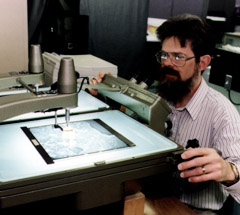
46, works for the Nova Scotia government's Geomatics Centre. With
years of experience in photogrammetry (the art and science of making
maps from aerial photos), he was put in charge of a complex coastal
mapping project that will eventually produce 117 maps at a scale
of 1:50 000, from the coast out to the twelve-mile limit.
Scheduled for completion in the spring of 2000,
the job requires a massive amount of co-ordination, both of data
and people. "It involves a lot of quality control work, a lot
of contracting out and specification development, a little bit
of programming, and a lot of paperwork," David says.
The coastal mapping project is making use of
both new aerial photography and existing maps, like those from
the Nova Scotia topographic and forestry databases, and charts
from the Canadian Hydrographic Service. Merging them is tricky
because the maps were created for different purposes, and are
not to the same scale.
David is also responsible for organizing the
work of the various contractors on the project, and making sure
that work is up to standard.
|
 |